A powerful magnitude 7.4 earthquake struck the Molucca Sea off Indonesia's North Maluku province early Thursday morning, killing at least one person, damaging buildings, and triggering tsunami warnings across the Pacific region before authorities lifted the alerts.
The earthquake occurred at 06:48 local time (22:48 GMT) at a depth of 35 kilometers, approximately 120 kilometers from Ternate island in North Maluku province, according to Indonesia's meteorology agency BMKG. The seismic event was felt across northern Indonesia, including North Sulawesi, and tremors were reported as far away as Singapore, Malaysia, and Brunei.
Immediate Impact and Casualties
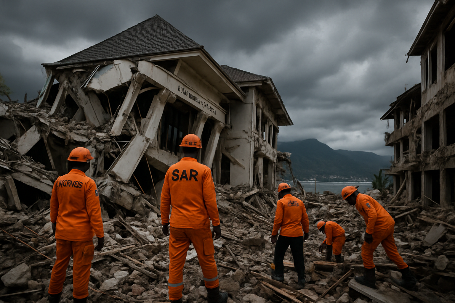
The earthquake claimed at least one life when part of a building used by North Sulawesi's National Sports Committee (KONI) collapsed in Manado, according to Deputy Chief of North Sulawesi police Awi Setiyono. The victim was killed by falling rubble, while another person was injured in the same incident.
Images from the scene showed police officers examining the damaged KONI building, with rubble and debris scattered on the ground. The collapse highlighted the vulnerability of older structures to seismic activity in this tectonically active region.
Indonesia's meteorology agency BMKG reported tsunami waves in five locations following the earthquake, with the highest wave reaching 0.75 meters (2.46 feet) in North Minahasa, North Sulawesi. Smaller waves of 0.3 meters were recorded along the North Maluku coast.
Regional Tsunami Warning System Activated
The earthquake triggered widespread tsunami alerts across the Pacific region. The US Tsunami Warning System issued alerts for a 1,000-kilometer radius, affecting Indonesia, the Philippines, Malaysia, Japan, Papua New Guinea, Taiwan, and Guam. The comprehensive warning demonstrated the effectiveness of international cooperation in tsunami preparedness systems developed following the devastating 2004 Indian Ocean tsunami.
BMKG chief Teuku Faisal Fathani explained during a press conference that the agency's modeling indicated tsunami potential for waves ranging from 0.5 to 3 meters (1.6 to 9.8 feet) in height. The warnings were gradually lifted as ocean monitoring systems confirmed that the tsunami threat had passed.
The Pacific Tsunami Warning Center coordinated with regional monitoring stations to provide real-time updates to coastal communities. The rapid response and coordinated international action showcased significant improvements in tsunami warning systems since the 2004 disaster that killed over 230,000 people across multiple countries.
Seismic Activity and Aftershocks
BMKG monitored 11 aftershocks following the main earthquake, with the largest registering magnitude 5.5. The agency warned the public to remain alert for potential additional seismic activity, as aftershock sequences can continue for days or weeks following a major earthquake.
Initial magnitude reports varied between different seismic monitoring stations, with some reporting the earthquake as strong as magnitude 7.8 before settling on the confirmed 7.4 magnitude. The variation in initial readings is common as seismic networks process data from multiple monitoring stations to determine the most accurate measurements.
The earthquake occurred in the complex tectonic zone where the Indo-Australian, Eurasian, and Philippine plates interact. This region, part of the broader Pacific Ring of Fire, experiences frequent seismic activity due to the ongoing collision and subduction of these major tectonic plates.
Historical Context and Regional Vulnerability
Indonesia sits on the Pacific Ring of Fire, a highly seismically active region that encircles the Pacific Ocean. The archipelago experiences thousands of earthquakes annually due to its position at the intersection of several major tectonic plates. Most are minor and cause no damage, but larger earthquakes pose ongoing risks to the nation's 273 million inhabitants.
The 2004 Indian Ocean earthquake and tsunami, which originated off the coast of Sumatra, remains one of the deadliest natural disasters in modern history. Since then, Indonesia has invested heavily in earthquake monitoring and tsunami warning systems, working closely with international partners to develop rapid response capabilities.
More recently, the region has experienced several significant seismic events, including the 2018 earthquake and tsunami in Central Sulawesi that killed over 4,000 people. These disasters have reinforced the importance of building earthquake-resistant infrastructure and maintaining effective early warning systems.
Emergency Response and Preparedness
Indonesian emergency services responded quickly to the earthquake, with search and rescue teams dispatched to affected areas to assess damage and assist injured residents. The relatively limited casualties compared to the earthquake's magnitude reflected both the deep epicenter location and improvements in building standards in many areas.
Local authorities across affected regions activated emergency protocols, with hospitals placed on alert and emergency services conducting damage assessments. The response demonstrated the effectiveness of disaster preparedness measures implemented following previous earthquakes and tsunamis.
The international community also stood ready to provide assistance if requested, with neighboring countries monitoring the situation and prepared to offer emergency aid. This regional cooperation reflects the shared vulnerability to natural disasters among Pacific Rim nations.
Geological Significance
The earthquake's depth of 35 kilometers classified it as a shallow earthquake, which typically causes more surface damage than deeper events of similar magnitude. However, the marine location reduced the impact on populated areas compared to a land-based earthquake of similar strength.
Seismologists noted that the earthquake's characteristics were consistent with the complex tectonic environment of the region. The Molucca Sea sits at the convergence of multiple tectonic plates, creating a highly active seismic zone where earthquakes of this magnitude can occur with relatively little warning.
The event provided valuable data for researchers studying earthquake mechanics in this region, contributing to ongoing efforts to improve earthquake prediction and hazard assessment capabilities. Understanding the patterns of seismic activity in this area remains crucial for protecting the millions of people living in earthquake-prone zones across Indonesia.
Looking Forward
As cleanup and recovery efforts continue in affected areas, authorities emphasized the importance of maintaining vigilance for potential aftershocks and continuing to strengthen earthquake preparedness measures. The earthquake served as a reminder of the ongoing seismic risks facing Indonesia and the broader Pacific region.
The successful coordination of the tsunami warning system and the relatively limited casualties demonstrated the progress made in disaster preparedness since the 2004 tsunami. However, officials stressed that continued investment in monitoring systems, building standards, and public education remains essential for protecting vulnerable populations in this seismically active region.
Climate scientists also noted that rising sea levels associated with climate change could potentially amplify the impact of future tsunami events, making continued vigilance and preparation even more critical for coastal communities across the Pacific.