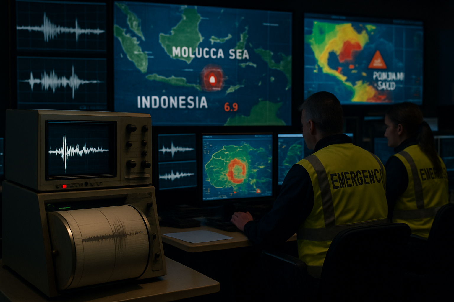
A magnitude 7.4 earthquake struck the Northern Molucca Sea off Indonesia's eastern coast early Thursday morning, triggering tsunami warnings across multiple Southeast Asian nations and generating small tsunami waves that reached Indonesian shores.
The powerful earthquake hit at 06:48 local time (22:48 GMT) near Indonesia's historic spice island of Ternate, according to the United States Geological Survey (USGS). The epicenter was located approximately 120 kilometers (75 miles) from Ternate, a coastal city in Indonesia's North Maluku province with a population of more than 200,000.
Initial Reports and Magnitude Discrepancies
Initial reports varied regarding the earthquake's magnitude, with some sources reporting 7.8 while others cited 7.4. The USGS later confirmed the magnitude as 7.4, with the earthquake occurring at a depth ranging from 10 to 35 kilometers, depending on the monitoring agency. The deeper readings significantly reduced the tsunami threat compared to initial assessments.
According to Norwegian authorities, the earthquake was initially reported as 7.8 magnitude at 10 kilometers depth but was later downgraded to 7.4 at 35 kilometers depth - a revision that experts noted makes it "far less dangerous" in terms of tsunami generation.
Tsunami Warnings and Response
The US Tsunami Warning System immediately issued alerts warning that hazardous tsunami waves could impact coastlines within a 1,000-kilometer radius of the epicenter. The warnings extended across multiple countries including Indonesia, the Philippines, Malaysia, Japan, Papua New Guinea, Taiwan, and Guam.
Indonesian authorities confirmed that tsunami waves approximately 0.3 meters (30 centimeters) high reached Indonesia's North Maluku province following the earthquake. While these waves were relatively small, they demonstrated the earthquake's potential to generate tsunamis despite the deeper epicenter.
Japanese meteorological authorities stated that while sea levels could rise somewhat, there was no significant danger of destruction. The Pacific Tsunami Warning Center indicated that tsunami wave heights could range between 30 centimeters and 1 meter in the most affected areas.
Regional Impact and Casualties
Despite the earthquake's significant magnitude, initial reports indicated minimal casualties and structural damage. Norwegian media reported one fatality, while Italian sources confirmed one death related to the seismic event. However, authorities reported some building damage in affected areas.
The earthquake was felt across a wide region, including tremors reported in Sabah and Sarawak (Malaysia), Singapore, Brunei, and throughout eastern Indonesia. The broad impact zone demonstrated the earthquake's substantial energy release despite occurring at a considerable depth.
Geological Context and Tectonic Setting
The earthquake occurred in the tectonically active Molucca Sea region, where the Indo-Australian, Eurasian, and Philippine tectonic plates interact in a complex subduction zone system. This area is part of the Pacific Ring of Fire, known for its high seismic and volcanic activity.
Indonesia experiences frequent earthquakes due to its position on several major fault lines. The country's geological setting makes it one of the most seismically active regions globally, with thousands of earthquakes occurring annually, though most are minor tremors.
Emergency Response and Monitoring
Indonesian emergency services immediately activated response protocols, with Fire and Rescue Operations Centers reporting no major injuries or casualties in the initial assessment period. The Malaysian Meteorological Department and other regional agencies maintained enhanced monitoring of the situation.
Coastal communities in affected areas followed established evacuation procedures, with many residents moving to higher ground as a precautionary measure. The response demonstrated the effectiveness of regional tsunami preparedness systems developed following the devastating 2004 Indian Ocean tsunami.
International Coordination
The earthquake response showcased the sophisticated regional warning systems established across the Pacific and Indian Oceans. Multiple countries' seismic monitoring networks provided rapid data sharing, enabling quick assessment of the tsunami threat and coordinated public warnings.
Regional cooperation agencies maintained communication throughout the event, with authorities in the Philippines, Malaysia, and other potentially affected nations issuing appropriate alerts to coastal populations while monitoring oceanographic conditions.
Historical Context and Recent Seismic Activity
This earthquake represents one of the more significant seismic events in the region in recent years, though Indonesia regularly experiences earthquakes of varying magnitudes. The country's position at the intersection of major tectonic plates ensures ongoing geological activity.
Recent seismic patterns across the Asia-Pacific region have included increased earthquake activity, with several nations reporting significant tremors in 2026. Scientific monitoring suggests this reflects normal tectonic processes rather than unusual geological instability.
Recovery and Ongoing Assessment
As of current reports, recovery efforts are focusing on damage assessment and ensuring the safety of coastal communities. Indonesian authorities continue monitoring for aftershocks, which are common following earthquakes of this magnitude.
The relatively limited damage despite the earthquake's significant magnitude highlights improvements in building codes and emergency preparedness across the region. Continued monitoring will assess any delayed impacts and provide data for future earthquake and tsunami preparedness efforts.
The incident serves as a reminder of the importance of regional cooperation in disaster preparedness and the value of modern seismic monitoring systems in protecting vulnerable coastal populations across Southeast Asia.